Events Calendar
Current Weather
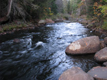
Whiskey Rapids Trail 
Description
Whiskey Rapids Trail is a 2.1 km loop trail leads along the Oxtongue River to scenic Whiskey Rapids. The trail guide discusses the ecology and history of an Algonquin river.
This trail often floods during times of high water in the Oxtongue River such as during spring melt and just after periods of extended heavy rain. A gate at Highway 60 and the trailhead parking lot will be closed and locked during unsafe conditions. Check Algonquin Park Current Advisories to see if this trail is currently closed.
Length
2.1 km
Location 
Whiskey Rapids Trail is located at km 7.2 of Highway 60. Latitude/Longitude: 45.485437°, -78.756241°
Difficulty Rating & Rationale
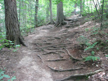
Moderate. This trail has a steep uphill section returning to the parking lot. Please note, that this trail regularly floods during spring melt and during periods of extended heavy rain. Check Algonquin Park Current Advisories to see if this trail is currently closed.
Theme
Algonquin River Ecology
Features & Amenities
- Scenic rapids along the Oxtongue River
- Parking
Trail Guide
Rules and Regulations
Protecting Visitors
Fees
A valid Park permit is required for trail use.
Nearby Attractions
Related Information
- Whiskey Rapids Trail Guide
- Whiskey Rapids Trail Crest
- Adopt-A-Trail
- Support the Trails - Make a Donation


Reserve your developed or backcountry campsite for your next visit.


Share your passion for Algonquin Park by becoming a member or donor.

Special regulations for Algonquin's special fishery.