Events Calendar
Current Weather
Brent Crater Trail 
Description
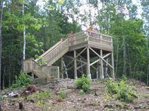
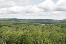
Brent Crater Trail is a 2.0 km loop near the Cedar Lake - Brent Access Point that allows scenic views and exploration of the Brent meteorite crater, one of the world's most famous fossil meteorite craters. Visitors can descend into the present floor of the crater before looping back to the observation tower overlooking the crater rim. The observation tower can also be accessed by a small parking lot off the Brent Road at km 32.
Length
2.0 km loop
Location 
Brent Crater Trail is located 32 km south of the Highway 17 on the Brent Road. The Brent Crater Trail is 8 km north of the Cedar Lake - Brent Access Point. Latitude/Longitude: 46.065562°, -78.459969°
Difficulty Rating & Rationale
- Moderate.
- Contact Algonquin Park Information for updates.
Theme
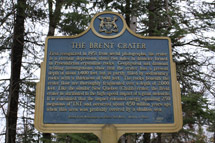
History of the Crater
Features & Amenities
- Views of the Brent Crater, one of the world's most famous fossil meteorite craters
- Exploration of the floor of the meteorite Brent Crater
- Shoreline of Tecumseh Lake
- Observation tower
- Exhibit panels
- Historical plaque
- Parking
Trail Guide
Rules and Regulations
Protecting Visitors
Fees
A valid Park permit is required for trail use.
Nearby Attractions
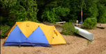
 Brent Campground
 Cedar Lake - Brent Access Point
 Brent Ranger Cabin
- North River Access Point
- Wendigo Lake Access Point
- Petawawa River Whitewater Guide
Related Information
- Brent Crater Trail Guide
- Brent Crater Trail Crest
- Adopt-A-Trail
- Support Your Trails - Make a Donation


Reserve your developed or backcountry campsite for your next visit.


Share your passion for Algonquin Park by becoming a member or donor.

Special regulations for Algonquin's special fishery.