Events Calendar
Current Weather
Cedar Lake - Brent Access Point (#27) 
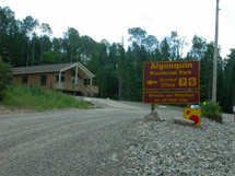
Location
Just west of Deux Rivières on Highway 17, turn south on Brent Road (gravel) and travel for 40 kilometres to the access point and Brent Campground on the north shore of Cedar Lake. Latitude and longitude of Access Point: 46.025477°, -78.486176°
Facilities
- Parking
- Toilets
- Campground
- Boat launch ramp
- Brent Ranger Cabin
- Brent Deputy Ranger Cabin
- Brent Historic Site Exhibit
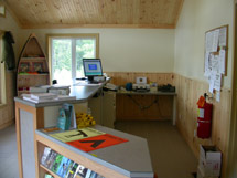
Access Point Office
Cedar Lake - Brent Access Point Office is located at km 0.5 of the Brent Road. This office is approximately 40 kilometres from the Brent Campground. Latitude and longitude of Permit Office: 46.243391°, -78.310421°
Backcountry Permits
Make a reservation for your backcountry camping permit up to 5 months in advance. Permits are only available online or via telephone.
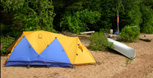
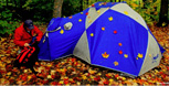
Equipment Rental
Do you need to rent a canoe, tent, or other camping equipment? Find a business that can supply some or all of the required equipment for your backcountry trip.
Water Levels
Check for special advisories prior to your departure at Algonquin Park Advisories.
Related Information
 Brent Campground
 Brent Ranger Cabin
- Brent Deputy Ranger Cabin
 Brent Crater Trail and Tower
- Petawawa River Whitewater Guide
- Wendigo Lake Access Point
- North River Access Point
- Kioshkokwi Lake - Kiosk Access Point
- Backcountry Canoeing
- Canoe Routes Map - Explore Online

Reserve your developed or backcountry campsite for your next visit.


Share your passion for Algonquin Park by becoming a member or donor.

Special regulations for Algonquin's special fishery.